PLANNING MEETING OF GRANT ROAD COALITION
GRANT ROAD COALITION MEETING - May 9, Ward III meeting Room
PLANNING MEETING of the Grant Road Coalition
May 9, 2024, 5:00 pm Ward III meeting Room
in person or by zoom:
https://us02web.zoom.us/j/89367155146?pwd=VUdBVmhUc1NHc21mVFZBYkNheUhnQT09
Meeting ID: 893 6715 5146 Passcode: 738657
The Grant Road Coalition will meet to review and plan for the next phase with a focus on greenspace and neighborhood mitigation.
Planning Paper - Information and Agenda May 9, 2024
Grant Road Central Segments Coalition WHITE PAPER FOR PHASES 5/6
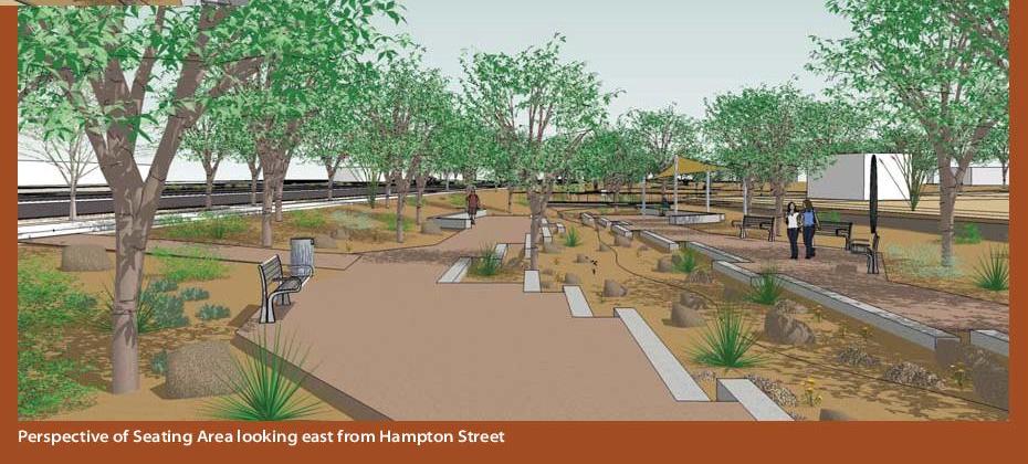
to see the Green Space "possibilities" for Phase 5 see: www.grantroad.info/pdf/Grant_5-6_Landscape_Opportunities_2021-04.pdfhttp://www.grantroad.info/pdf/Grant_5-6_Landscape_Opportunities_2021-04.pdf
FIRST TO TUCSON BLVD "CENTRAL SEGMENTS" - Grant Road Coalition
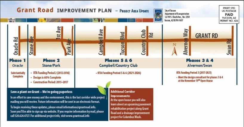
The Grant Road Improvement Project extends from Oracle to Swan Road. Phase two and Phase five effect Jefferson Park and four other neighborhoods. The widening of Grant Road will cause the loss of 23 properties which contribute to Jefferson Park's historic status. Other neighborhoods face issues of mitigation of sound, light and safety.
The "Grant Road Coalition" is composed of five residential areas contiguous to Grant Road. For more information on the coalition contact Joan Daniels, Jefferson Park Representative; or Barbara Miller, SAMOS representative.
The "Grant Road Coalition" is composed of five residential areas contiguous to Grant Road. For more information on the coalition contact Joan Daniels, Jefferson Park Representative; or Barbara Miller, SAMOS representative.
Purpose:
1) To establish an interface between the Grant Road Project and the historic and residential neighborhoods along the one mile between First Ave and Tucson Blvd .
2) To represent and inform the neighborhood residents and associations in the affected area. To facilitate their voice in the process.
Goals:
MEMBERSHIP
Jefferson Park Neighborhood Members
* JPNA Coalitiion Co-chair, J Daniels [email protected]
Members: B. Schlanger, J. Osuna, Colleen NIchols
SAMOS Neighborhood
* SAMOS Coalition Co-chair, Bam Miller [email protected]
Mountain/First Neighborhood
* Mtn/First Co-chair, Sarah Studd
Campbell/Grant Neighborhood
*Campbell/Grant Co-shair, Ben Elias
Catalina Vista
*Catalina Vista Co-chair, Janet Fischer
GOVERNMENTAL ENTITIES INVOLVED
DTM, Department of Transportation and Maintenance
Grant Road Improvement Project (GRIP) Citizens Task Force
WARD III, WARD VI
1) To establish an interface between the Grant Road Project and the historic and residential neighborhoods along the one mile between First Ave and Tucson Blvd .
2) To represent and inform the neighborhood residents and associations in the affected area. To facilitate their voice in the process.
Goals:
- Preserve the historic and cultural vision for the border of the impacted residential and historic neighborhoods.
- Enhance and maintain the vitality of inner city neighborhoods
- Promote the use of walls, berms, green space, bikeways, and pedestrian facilities encouraging transit, and provision for smooth traffic flow.
- Promote the best practice in urban planning and development which protects and preserves the quality of life of inner city neighborhoods.
- Protect the R-1, NPZ already existing in the mile.
- minimize the impact of the demolitions on the National Historic District status of Jefferson Park.
MEMBERSHIP
Jefferson Park Neighborhood Members
* JPNA Coalitiion Co-chair, J Daniels [email protected]
Members: B. Schlanger, J. Osuna, Colleen NIchols
SAMOS Neighborhood
* SAMOS Coalition Co-chair, Bam Miller [email protected]
Mountain/First Neighborhood
* Mtn/First Co-chair, Sarah Studd
Campbell/Grant Neighborhood
*Campbell/Grant Co-shair, Ben Elias
Catalina Vista
*Catalina Vista Co-chair, Janet Fischer
GOVERNMENTAL ENTITIES INVOLVED
DTM, Department of Transportation and Maintenance
Grant Road Improvement Project (GRIP) Citizens Task Force
WARD III, WARD VI
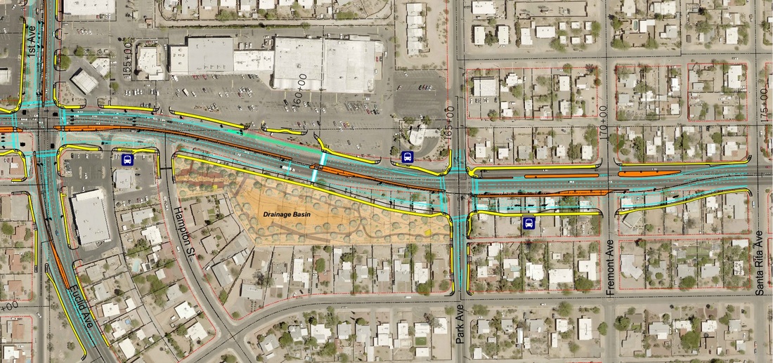
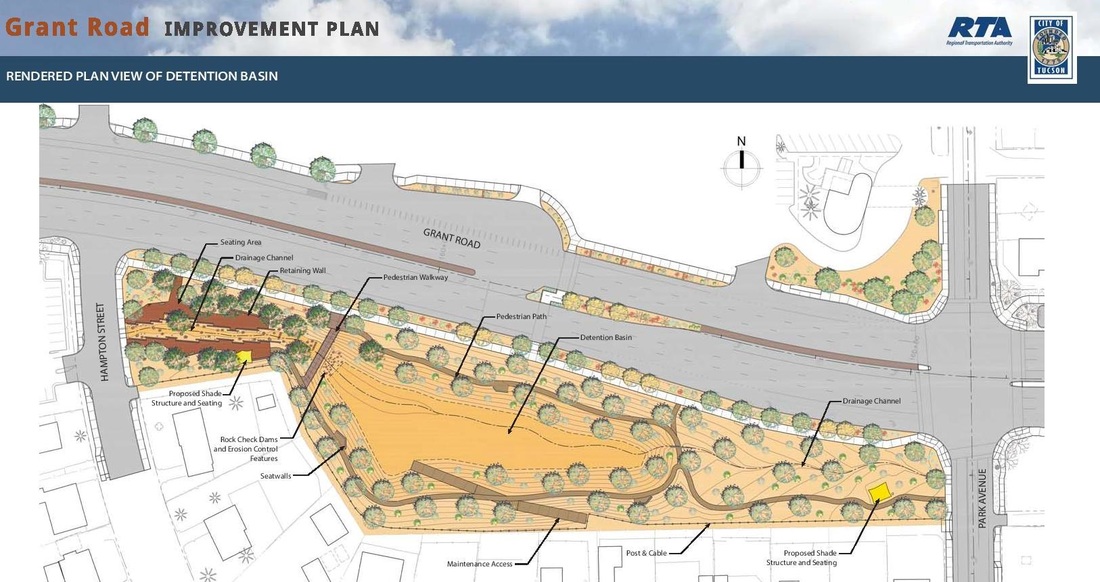
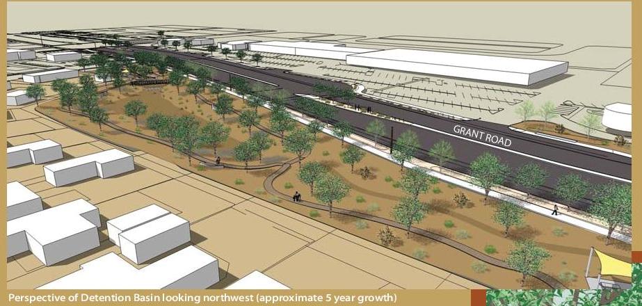
AN URBAN PARK AND HEALTH TRAIL - NOT FUNDED: The City of Tucson in partnership with the RTA, PAG and the Grant Road Coalition-Central Segments submitted this grant to the State on May 7. It was the top rated grant in the state and was forwarded to the federal level for consideration. There will be 15 awarded and winners will be announced in October 2016. This unique concept addresses the area from Park Avenue to Santa Rita along Grant Road.
90% Phase ii Grant Road aligment
Click here to see city website version of map where you can enlarge and scroll.
|
|